Castillo Real (Royal Castle)A Maya site on the eastern coast,
near the northern tip of the island, the castillo
(castle) comprises a lookout tower, the base of a
pyramid, and a temple with two chambers capped by a false
arch. The waters here harbor several shipwrecks, remnants
from the days when buccaneers lay in wait for richly
cargoed galleons en route to Europe. It's a fine spot for
snorkeling because there are few visitors to disturb the
fish.
Chankanaab Parque
Natural (Chankanaab Nature Park)
Chankanaab (the name means "small sea"), a
10-minute drive south of San Miguel, is a lovely
saltwater lagoon that the government has made into a
wildlife sanctuary, botanical garden, and archaeological
park. The treasures from the Cozumel Archaeological
Park--Toltec, Mexican, and Maya statues and stone
carvings--have recently found a new home here. Underwater
caves, offshore reefs, a protected bay, and a sunken ship
attract droves of snorkelers and scuba divers. The
botanical garden boasts about 350 varieties of plant life
from more than 20 countries, and scattered throughout are
reproductions of Maya ruins and typical living quarters.
Some 60-odd species of marine life, including fish,
coral, turtles, and various crustaceans, reside in the
lagoon; however, a major scientific study is currently
under way, so swimming through the underwater tunnels
from the lagoon to the bay or walking through the shallow
lagoon is no longer permitted. Still, there's plenty to
see in the bay, which hides crusty old cannons and
anchors as well as statues of Jesus Christ and Chac Mool.
El Cedral
Once the tiny village and ruins comprised the largest
Maya site on Cozumel: This was the temple sighted by the
original Spanish explorers in 1518, and the first Mass in
Mexico was reportedly celebrated here. These days,
there's little archaeological evidence of El Cedral's
past glory. Conquistadors tore down much of the temple,
and at the turn of this century the site was uninhabited.
The U.S. Army Corps of Engineers destroyed most of the
rest of the ruin during World War II to make way for the
island's first airport, and now all that remains is a
small structure capped by jungle growth; its Maya arch,
best viewed from inside, is covered by faint traces of
paint and stucco. Numerous small ruins are hidden in the
heavy growth of the surrounding area, but you'll need a
guide (there are usually one or two hanging around the
main ruin) to find them. Every May a fair, with dancing,
music, and a cattle show, is held here. After exploring
the ruins, you can take a rest nearby in a small
green-and-white cinder-block church, typical of rural
Mexico. Inside, a number of crosses are shrouded in
embroidered lace. During religious festivals the simple
room is adorned with folk art.
Isla de Pasi¾n
Beyond Punta Norte, in the middle of Abrigo Bay, this
tiny island is now part of a state reserve. Fishing is
permitted and the beaches are secluded, but there are no
facilities on the island, and since so few people go,
there are no scheduled tours. You'll have to bargain with
a local boat owner for transportation if you want to
visit.
Laguna Colombia
(Colombia Lagoon)
A prime site for jungle aficionados, this lagoon lies at
the island's southern tip and is most commonly reached by
boat, although there is a trail. Fish migrate here to lay
their eggs, and barracuda, baby fish, and birds show up
in great numbers in season. There are popular diving and
snorkeling spots offshore in the reefs of Tunich,
Colombia, and Maracaibo.
Punta Celerain Faro
(Punta Celerain Lighthouse)
Located on the southernmost tip of the island, the
lighthouse is surrounded by sand dunes at the narrowest
point of land. It affords a misty, mesmerizing view of
pounding waves, swamps, and scraggly jungle. Alligators
were once hunted nearby; nowadays you may spot a soldier
or two from the adjacent army post catching an iguana.
The point comes to life at midday when the lighthouse
keeper serves fried fish and beer, and locals and
tourists gather to chat; Sundays are particularly
popular. The lighthouse is at the end of a 4-km-long
(2-1/2-mi-long) dirt road--you'll need a four-wheel-drive
vehicle if you plan to visit.
Punta Molas Faro
(Punta Molas Lighthouse)
If you are going to attempt to reach the northernmost tip
of the island, be sure you have plenty of time and a
reliable four-wheel-drive vehicle. While exploring this
area keep alert for possible sightings of crocodiles, boa
constrictors, and scorpions. They prefer not to have
contact with humans, so it's unlikely that they would
interfere with your visit, but the unexpected can happen.
The lighthouse is an excellent spot for sunbathing,
birding, and camping. Although this entire area is
accessible only by four-wheel-drive vehicles or by boat,
the jagged shoreline and the open sea offer magnificent
views, making it well worth the trip.
San Gervasio
These ruins of the largest existing Maya and Toltec site
on Cozumel are worth visiting. San Gervasio was once the
island's capital and probably its ceremonial center,
dedicated to the fertility goddess Ixchel. The Classic-
and Post-Classic-style site was continuously occupied
from A.D. 300 to A.D. 1500. Typical architectural
features from the era include limestone plazas and
masonry superstructures atop stepped platforms, as well
as stelae, bas-reliefs, and frescoes. What remains today
are several small mounds scattered around a plaza and
several broken columns and lintels that were once part of
the main building or observatory. Each of the ruins is
clearly identified and explained on three-language
plaques (Maya, Spanish, and English) and placed in
context with individual maps. There are a snack bar and
some gift shops at the entrance. To get here take the
cross-island road (Av. Jußrez) to the San Gervasio
access road; follow this road north for 7 km (4-1/2 mi).
More likely than not the ruin will close during October.
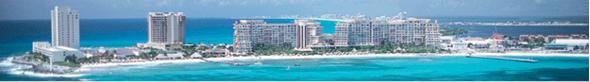
San Miguel
Cozumel's only town retains the laid-back tenor of a
Mexican village, although its streets are dotted with an
interesting variety of shops and restaurants. Avenida
Rafael Melgar, San Miguel's waterfront boulevard, has a
wide cement walkway, called the malec¾n. The malec¾n
separates Avenida Rafael Melgar from the town's narrow
sandy beach. As in most Mexican towns, the main square,
here called the Plaza del Sol, is where
townspeople and visitors hang out, particularly on Sunday
nights when mariachi bands join the nightly assortment of
food and souvenir vendors.
Museo de la Isla de
Cozumel (Museum of the Island of Cozumel) is housed
on two floors of what was once the island's first luxury
hotel. Four permanent exhibit halls of dioramas,
sculptures, and charts explain the island's history and
ecosystem. Well laid-out and labeled displays cover
pre-Hispanic, colonial, and modern times and detail the
local geology, flora, and fauna. Among the highlights is
a charming reproduction of a Maya house. The museum also
presents temporary exhibits, guided tours, and workshops.
Av. Rafael Melgar between Calles 4 and 6 Norte,
987/21475. Admission: $3. Hours: 10-6
|